In order to reduce the risk of an earthquake and reduce and mitigate its effects, it is necessary to predict where and when a future, large earthquake may occur. For example, it would be important to know when such an earthquake will hit, where it will strike, and what the level of its destructiveness may be. Earthquake prediction at the present time is not an exact science, and forecasts of earthquake occurrences have not been very accurate. Presently predictions are given in statistical terms.
For example, when a prediction is made that : here is a 90% chance that an earthquake will occur in the next 50 years”, it does not mean that this earthquake cannot happen tomorrow or it may not be delayed by 50 years. Thus, present predictions are not within a reasonable time frame that can be of usefulness to planners, policy makers, and those in government that deal with public safety.
To understand earthquake prediction, three different time frames have been assigned by scientists: long term, intermediate and short-term predictions. Long term prediction involves a time frame of a decade or more and can only be general and with very limited usefulness for public safety. Intermediate term prediction would fall into a time span of a few weeks to a few years, and again it would not be of great practical usefulness. It is the short-term prediction, that is specific information on the time and location of an earthquake given within days, weeks, months – not years – that would be useful for any kind of public safety and evacuation.
Several specific geophysical, geological, and chemical methods are presently used for earthquake prediction. To the list of geological and geophysical events and precursors we should add one more method that has been used with much success in China: that is the monitoring the behavior of animals before quakes.
Within the last 24 hours, 45 earthquakes of magnitude 2.5 or greater have struck Alaska, and 25 of them were of magnitude 4.0 or greater. The worst one had a magnitude of 6.2, but none of the earthquakes did much damage because none of them hit heavily populated areas. But the reason why all of this shaking is causing so much concern is because the “Ring of Fire” runs right along the southern Alaska coastline, and all of the earthquakes except for one were along the southern coast.
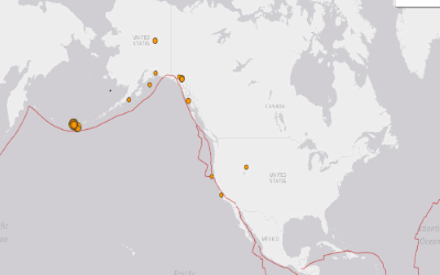
After running along the southern Alaska coastline, the Ring of Fire goes south along the west coast of Canada, the United States and Mexico. What affects one part of a fault network will often trigger something along another portion of the same fault network, and so many living on the west coast are watching the shaking in Alaska with deep concern.
Tuesdays “violent” Magnitude 7.1 earthquake near Mexico City has not had any after-shocks. NONE! Geologists are now panicking that the strong quake was, in fact, a “FORESHOCK” of a very much LARGER EARTHQUAKE coming within a day or two.
The last time a Magnitude 7 or above earthquake took place with NO aftershocks was ONE DAY before the staggering Magnitude 9.2 which destroyed much of Japan in March, 2011.
The fact that there have been no aftershocks from the Mexico quake means something utterly horrific is quite likely either for that area or, worse, somewhere else along the same (or nearby) fault system.
It is also worth noting that Tuesday’s Magnitude 7.1 was farther NORTH than the several weeks previous Magnitude 8.4 which struck in Mexico. So the tension is moving NORTH . . . . toward California.
It is worth noting that the same – and nearby – fault system connects directly to the San Andreas Fault running through California.
For a long time scientists have acknowledged that a major Cascadia subduction zone earthquake is way overdue, and when one finally strikes the devastation that we could see in the Pacific northwest is likely to be off the charts. In fact, some scientists believe that the coming Cascadia subduction zone earthquake could potentially be as high as magnitude 9.0…
The Cascadia Subduction Zone off the coast of North America spans from northern California to southern British Columbia. This subduction zone can produce earthquakes as large as magnitude 9 and corresponding tsunamis.
Just in case you missed it…and you probably did…FEMA Will Hold A Drill To Prepare For A 9.0 Cascadia Subduction Zone Earthquake And Tsunami next week.
Just in case you missed it…and you probably did…there is a gargantuan, 700 mile long quake-maker referred to as the Cascadia Subduction Zone that rests at the bottom of the Pacific Ocean off the coast of the American northwest where the seabed meets the North American tectonic plate. According to experts, this behemoth has the potential to unleash the worst natural disaster in the history of North America should it rupture entire.
FEMA will be conducting a large scale drill that has been named “Cascadia Rising” that will simulate the effects of a magnitude-9.0 earthquake along the Cascadia Subduction Zone and an accompanying west coast tsunami dozens of feet tall.
According to the official flier for the event, more than “50 counties, plus major cities, tribal nations, state and federal agencies, private sector businesses, and non-governmental organizations across three states—Washington, Oregon and Idaho—will be participating.”
In addition to “Cascadia Rising,” U.S. Northern Command will be holding five other exercises simultaneously. According to the final draft of the Cascadia Rising drill plan, those five exercises are entitled “Ardent Sentry 2016,″ “Vigilant Guard,” “Special Focus Exercise,” “Turbo Challenge” and “Joint Logistics Over-the-Shore.” The primary scenario that of all of these participants will be focusing on will be one that involves a magnitude 9.0 earthquake along the Cascadia Subduction Zone followed by a giant tsunami that could displace up to a million people from northern California to southern Canada.
We have never seen such a disaster before in all of U.S. history.
Do they know something that the rest of us do not?
It is funny that they are preparing to deal with the effects of a magnitude-9.0 earthquake along the Cascadia Subduction Zone, because that is precisely the size of earthquake that I warned about in an article back in March.
The San Andreas Fault in southern California gets more headlines, but the Cascadia Subduction Zone is a much larger threat by far. This fault zone is where the Juan de Fuca plate meets the North American plate, and it stretches approximately 700 miles from northern Vancouver Island all the way down to northern California.
If a magnitude-9.0 earthquake were to strike, the immense shaking and subsequent tsunami would cause damage on a scale that is hard to even imagine right now. Perhaps this is why FEMA feels such a need to get prepared for this type of disaster, because the experts assure us that it is most definitely coming someday. The following comes from the official website of the “Cascadia Rising” exercise:
A 9.0 magnitude earthquake along the Cascadia Subduction Zone (CSZ) and the resulting tsunami is the most complex disaster scenario that emergency management and public safety officials in the Pacific Northwest could face. Cascadia Rising is an exercise to address that disaster.
Emergency Operations and Coordination Centers (EOC/ECCs) at all levels of government and the private sector will activate to conduct a simulated field response operation within their jurisdictions and with neighboring communities, state EOCs, FEMA, and major military commands.
If you don’t think that the scenario that they are studying is realistic, perhaps you should consider the fact that the largest earthquake in the history of the continental United States stuck along the Cascadia Subduction Zone back in 1700. The following comes from CNN:
In fact, “the Cascadia” already has made history, causing the largest earthquake in the continental United States on January 26, 1700. That’s when the Cascadia unleashed one of the world’s biggest quakes, causing a tsunami so big that it rampaged across the Pacific and damaged coastal villages in Japan.
Yes, we all remember the big Hollywood blockbuster about the San Andreas fault. But if they wanted to be more realistic, they should have made the movie about the Cascadia Subduction Zone. According to a professor of geophysics at Oregon State University, the Cascadia Subduction Zone has the potential to create an earthquake “almost 30 times more energetic” than anything the San Andreas Fault can produce.
Everyone knows the Cascadia’s cousin in California: the San Andreas Fault. It gets all the scary glamor, with even a movie this year, “San Andreas,” dramatizing an apocalypse in the western U.S.
Truth is, the San Andreas is a lightweight compared with the Cascadia.
The Cascadia can deliver a quake that’s many times stronger — plus a tsunami.
“Cascadia can make an earthquake almost 30 times more energetic than the San Andreas to start with, and then it generates a tsunami at the same time, which the side-by-side motion of the San Andreas can’t do,” said Chris Goldfinger, a professor of geophysics at Oregon State University.
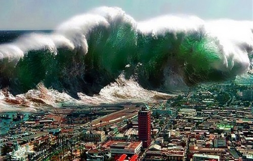
And the kind of tsunami that would be created by such a massive quake along the Cascadia Subduction Zone would absolutely dwarf the massive tsunami that struck Japan back in 2011. In fact, an article in the New Yorker quoted the head of the FEMA division that oversees Oregon, Washington, Idaho and Alaska as saying that “everything west of Interstate 5 will be toast.”
If the entire zone gives way at once, an event that seismologists call a full-margin rupture, the magnitude will be somewhere between 8.7 and 9.2. That’s the very big one.
… By the time the shaking has ceased and the tsunami has receded, the region will be unrecognizable. Kenneth Murphy, who directs FEMA’s Region X, the division responsible for Oregon, Washington, Idaho, and Alaska, says, “Our operating assumption is that everything west of Interstate 5 will be toast.”In the Pacific Northwest, everything west of Interstate 5 covers some hundred and forty thousand square miles, including Seattle, Tacoma, Portland, Eugene, Salem (the capital city of Oregon), Olympia (the capital of Washington), and some seven million people.We live at a time when the crust of our planet is becoming increasingly unstable. Based on my research, I have come to the conclusion that we will soon see major earth changes on a scale that most of us would never even dare to imagine.All over the world the Ring of Fire is roaring to life, and the Cascadia Subduction Zone lies directly along the Ring of Fire. Just last week, I wrote about the alarming earthquake swarms that we have seen directly under Mt. Rainier, Mt. Hood and Mt. St. Helens, and now we have learned that FEMA is about to hold a major drill that is going to simulate a magnitude-9.0 earthquake along the Cascadia Subduction Zone and an accompanying west coast tsunami dozens of feet in height.Of course most Americans aren’t concerned about this threat at all.Most Americans just assume that life will continue to go on normally just as it always has.But I happen to agree with the experts that are promising us that an absolutely massive earthquake along the Cascadia Subduction Zone will strike someday, and when that happens life in America will be permanently altered.


Former White House space program adviser, consultant to NASA headquarters, space shuttle engineer, author, and CEO of Earthquake and Prediction Center,John L. Casey, shares life-saving intel about what FEMA is not telling you about earthquakes, volcanic activity, and solar hibernation.
John Casey issued a warning letter to FEMA, warning that the world would be heading into a “solar hibernation” period, a period that historically has been proven to cause upticks in catastrophic seismic and volcanic activity. Unfortunately, FEMA and the government are ignoring the multiple warnings sent from his institute.
According to Casey:
“We believe the USA and the world, has now entered the most dangerous period for catastrophic earthquakes and volcanic eruptions in over two hundred years….It would be foolhardy to ignore in particular, the history of major earthquakes in the New Madrid Seismic Zone and the fact that at the bottom of every solar hibernation for the past 600 years, that area has seen devastating earthquakes ranging from M6.8 to M8.0.”
Why would FEMA and the government continually ignore repeated warnings that could save lives here in America? What earthquakes have a more likely chance of going off and how much time do we have left before the “big one”? All that and more in this CRUCIAL report they are attempting to suppress!

A Tsunami Will Hit The East and West Coast Lines From An Unusual Event- ” I saw one of the things that I talked about was a tsunami. It was going to hit both coasts. One was going to hit the east coast, and one was going to hit the west coast. I talked a little bit about that, and so, no I don’t know anything about timing, I do know that there is one coming from an unusual event, which I probably shouldn’t have said that, but there is one coming. What I saw hit New York City, and I am not sure how far down the east coast it came, so I am not sure if it hits the Myrtle Beach area, or not, I just saw it hit New York City and somewhere south of there, and north of there was hit. And then I saw one coming to the west coast, and hitting LA, and several of the buildings that were 7 to 10 stories tall were under water “ John Paul Jackson
Geologists are out with a startling warning that Southern California is overdue for a major and possibly catastrophic earthquake. A new study says it’s expected to hit along the San Andreas Fault north of Los Angeles. It could have a magnitude of 7.5 or higher. CBS News science and futurist contributor Michio Kaku, a physics professor at the City University of New York, joins “CBS This Morning” to discuss the threat.
Survival Food Prepping Ideas/ULTIMATE Top Skills 2017
Discover how to survive: Most complete survival tactics, tips, skills and ideas like how to make pemmican, snow shoes, knives, soap, beer, smoke houses, bullets, survival bread, water wheels, herbal poultices, Indian round houses, root cellars, primitive navigation, and much more at: The Lost Ways
Here’s just a glimpse of what you’ll find in The Lost Ways:
From Ruff Simons, an old west history expert and former deputy, you’ll learn the techniques and methods used by the wise sheriffs from the frontiers to defend an entire village despite being outnumbered and outgunned by gangs of robbers and bandits, and how you can use their wisdom to defend your home against looters when you’ll be surrounded.
Native American ERIK BAINBRIDGE – who took part in the reconstruction of the native village of Kule Loklo in California, will show you how Native Americans build the subterranean roundhouse, an underground house that today will serve you as a storm shelter, a perfectly camouflaged hideout, or a bunker. It can easily shelter three to four families, so how will you feel if, when all hell breaks loose, you’ll be able to call all your loved ones and offer them guidance and shelter? Besides that, the subterranean roundhouse makes an awesome root cellar where you can keep all your food and water reserves year-round.
From Shannon Azares you’ll learn how sailors from the XVII century preserved water in their ships for months on end, even years and how you can use this method to preserve clean water for your family cost-free.
Mike Searson – who is a Firearm and Old West history expert – will show you what to do when there is no more ammo to be had, how people who wandered the West managed to hunt eight deer with six bullets, and why their supply of ammo never ran out. Remember the panic buying in the first half of 2013? That was nothing compared to what’s going to precede the collapse.
From Susan Morrow, an ex-science teacher and chemist, you’ll master “The Art of Poultice.” She says, “If you really explore the ingredients from which our forefathers made poultices, you’ll be totally surprised by the similarities with modern medicines.” Well…how would you feel in a crisis to be the only one from the group knowledgeable about this lost skill? When there are no more antibiotics, people will turn to you to save their ill children’s lives.
If you liked our video tutorial on how to make Pemmican, then you’ll love this: I will show you how to make another superfood that our troops were using in the Independence war, and even George Washington ate on several occasions. This food never goes bad. And I’m not talking about honey or vinegar. I’m talking about real food! The awesome part is that you can make this food in just 10 minutes and I’m pretty sure that you already have the ingredients in your house right now.
Really, this is all just a peek.
The Lost Ways is a far-reaching book with chapters ranging from simple things like making tasty bark-bread-like people did when there was no food-to building a traditional backyard smokehouse… and many, many, many more!
And believe it or not, this is not all…
Table Of Contents:
The Most Important Thing
Making Your Own Beverages: Beer to Stronger Stuff
Ginger Beer: Making Soda the Old Fashioned Way
How North American Indians and Early Pioneers Made Pemmican
Spycraft: Military Correspondence During The 1700’s to 1900’s
Wild West Guns for SHTF and a Guide to Rolling Your Own Ammo
How Our Forefathers Built Their Sawmills, Grain Mills,and Stamping Mills
How Our Ancestors Made Herbal Poultice to Heal Their Wounds
What Our Ancestors Were Foraging For? or How to Wildcraft Your Table
How Our Ancestors Navigated Without Using a GPS System
How Our Forefathers Made Knives
How Our Forefathers Made Snow shoes for Survival
How North California Native Americans Built Their Semi-subterranean Roundhouses
Our Ancestors’Guide to Root Cellars
Good Old Fashioned Cooking on an Open Flame
Learning from Our Ancestors How to Preserve Water
Learning from Our Ancestors How to Take Care of Our Hygiene When There Isn’t Anything to Buy
How and Why I Prefer to Make Soap with Modern Ingredients
Temporarily Installing a Wood-Burning Stove during Emergencies
Making Traditional and Survival Bark Bread…….
Trapping in Winter for Beaver and Muskrat Just like Our Forefathers Did
How to Make a Smokehouse and Smoke Fish
Survival Lessons From The Donner Party
Books can be your best pre-collapse investment.
The Lost Ways (Learn the long forgotten secrets that helped our forefathers survive famines,wars,economic crisis and anything else life threw at them)
Survival MD (Best Post Collapse First Aid Survival Guide Ever)
Conquering the coming collapse (Financial advice and preparedness )
Liberty Generator (Build and make your own energy source)
Backyard Liberty (Easy and cheap DIY Aquaponic system to grow your organic and living food bank)
Bullet Proof Home (A Prepper’s Guide in Safeguarding a Home )
Family Self Defense (Best Self Defense Strategies For You And Your Family)
Survive Any Crisis (Best Items To Hoard For A Long Term Crisis)
Survive The End Days (Biggest Cover Up Of Our President)
Drought USA (Discover The Amazing Device That Turns Air Into Water)